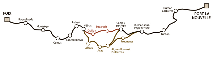
The Cathar Way is a 250km footpath in the French Pyrenees. It runs between Port La Nouvelle on the Mediterranean coast to the historic town of Foix.
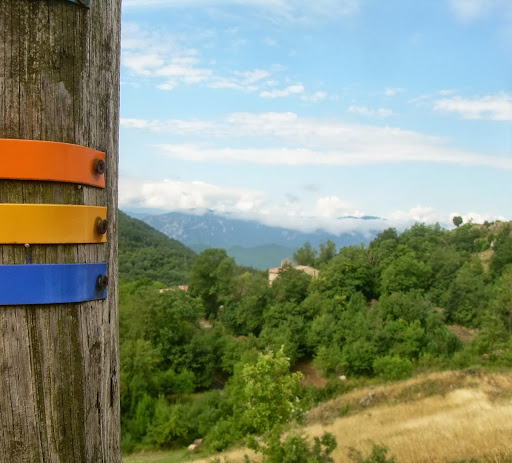
It’s a well-marked trail, followed by looking out for posts with coloured markings.
Much of the path is in the foothills of the Pyrenees and takes in many castles and fortifications built by the Cathars between the 12th and 14th centuries.
My hikes on the Cathar Way
Saint Julia de Bec to Maury (2013)
My hike was in mid-August (hot!), I walked for four days, starting at the tiny village of Saint Julia de Bec and finishing up in the town of Maury, some 50 km to the east. I camped two nights and spent the final night in a gite.
- Day one: Saint Julia de Bec to Bugarach
- Day two: Bugarach to Cubières-sur-Cinoble
- Day three: Cubières-sur-Cinoble to Duilhac-sous-Peyrepertuse
- Day four: Duilhac-sous-Peyrepertuse to Maury
It was hot! Mid August is probably not the best time to go hiking in the south of France but that was the only time I had available. The secret is to start walking early, between 6.30 and 7.30am, and get the main part of the hike over by 11am. By midday it became very hard work in the open and I was constantly looking out for shady areas.
The hills are gorgeous at that time of the morning so it’s well worth getting up then anyway.
Coudons to Axat (2016)
Guide books
I used ‘Walk! the Cathar Way’ by Charles Davis and The Cathar Way by Alan Mattingly. Charles Davis’ book follows the trail from west to east (Alan Mattingly’s goes from east to west) which was my direction so that was the one I used the most (I find it hard following directions back to front!).
Davis’ book is PDF-only, which is very handy which meant I could print off the pages I needed and kept the relevant one handy in my shirt pocket. Much easier (and less weight) than having to continuously flick through a book.
(with thanks to Anne for making it all possible)
Sounds like a walk I would enjoy…
I think you would enjoy the walk Sally, it’s very beautiful
Unusual Martin . Pyrenees are beautiful . You will be outstripping dan Brown
Glad you enjoyed the post Bob.